31 January 2011

Tornado sirens mean TAKE SHELTER/NWR reminder.

As a storm chaser I LOVE the sound of tornado sirens, especially if there is a visible tornado. However it is bittersweet since for there to be tornado sirens, there needs to be people in the vicinity of the tornado and that is always a horrible situation. I do not like destruction or deaths so don't get the wrong impression when I say I like the sound of tornado sirens. Every time my home town goes under a warning and I am not chasing, I always go out there and video the storm coming in with the sirens blaring. I know storm structure and how to read radar so I know if I wasn't in any immediate danger I can stay out there through the duration of the storm. With that being said...

Why is it every time I am out on a chase and going through a town with sirens blaring I see 1,000 people standing out on their front porches or in the streets looking in the wrong direction. Is it possible that these people are as educated as storm chasers or are spotters themselves and can pick out danger as they see it? I guess. Is it probable that ALL those people are? Absolutely not. I guess I can't understand why people want to go out of their safe place to view and observe the storm when they may not even be able to see it. Do people take tornado sirens for granted? Do they even know why they are going off? Do they even notice they are going off? I don't know. I am not a social scientist or claim to speak for other people. Although a popular notion out there is that "it can't happen to me." Talk to the poor people of Greensburg, KS, Plainfield, IL, or Parkersburg, IA. Devastating tornadoes decimated those towns and unfortunately caused fatalities. I know in the case of Greensburg all the residents did act in an appropriate manner, the tornado was just that powerful that it killed 9 people in their basements. Storm chaser reports, National Weather Service warnings, and the media saved lives but did sirens save lives? I can't answer that and won't even speculate in those cases out of respect for those who have lost everything.

I can talk about cases I have witnessed first hand though. Normally my neighborhood is pretty vigilant of warnings. When the sirens go off people get off the streets and get inside their homes, whether they are taking shelter in the basement is beyond me. But the point is, people aren't flocking the streets like the 4th of July parade. Let me post an example....

May 19th, 2010: While chasing a newly tornado warned supercell near Norman, OK we were on the southwest side of town as the warning was issued. The sirens started to blare and as we drove past a couple subdivisions we noticed people outside walking around and gathering in fields to watch. As we headed south to Purcell and Lexington it was the same story. Everyone was outside and looking around. It was as if the tornado sirens signaled a party was started. The Norman area was hit by an EF-4 tornado 9 days before this and people were out gawking and looking in the wrong directions for the tornado. Is there some standard in Oklahoma that says you can't take shelter unless you visually see a tornado coming? This isn't a bash on Oklahomans because I have seen in Kansas, Nebraska, and Illinois.

Above video used with Ben Holcomb's permission

People need to remember that tornado sirens signal that you are under a warning. Not that you need to come outside and survey things yourself. Will anyone ultimately be killed because they walked outside because they wanted to see it before they believed it? Probably not. But I fear it takes a devastating event (I.E strong tornado hitting their town) before that thought of "it can't happen to me" fades away.

Another striking example was on May 22nd, 2010. As the wedge was moving to the northwest of town, the town itself had tornado sirens blaring. As we passed by the town we could see the wedge on the buildings to the NW but people facing east and south west pointing at the sky totally oblivious to the giant tornado a couple miles to their north. To this day I don't think some of those people truly realize how LUCKY they were to have God on their side and to have this likely EF-5 tornado (opinion) narrowly miss them.

Wedge tornado in progress behind buildings while residents look in the opposite direction

I was going to spin this blog toward posing the question if tornado sirens really are a help or hindrance to the warning process.... but I am smarter than that. I know they DO serve their purpose, but it is up to you and me as individuals to make smart choices. If we choose to step outside and gawk at the sky and end up become a human missile, then we only have ourselves to blame. Point of the blog was for those of us in the weather community to drive home the point to warn those who aren't living and breathing weather 24/7 to take shelter. A great present for anyone for their birthday and/or Christmas is a NOAA weather radio. Even set it up for them and put it in the corner or something. Enter the SAME codes in to their county or the adjacent counties and let the radio do its' job. Unless you live close to a siren, you probably will never hear it during a storm and especially in the middle of the night.

So please I recommend us to remind loved ones when the sirens blow they have to go for shelter. They may run to the shelter 99 times a year but on that 100th time that they don't could end up catastrophic. Severe weather season is only a month away. Make sure you have batteries for your radio and a disaster plan or designated tornado shelter. Pre-plan and practice so when the time comes you and your family can get there in a quick efficient manner. Things can be replaced, humans can't.

Stay safe readers!
Danny.

29 January 2011

Rant: Tornado types/Difference in opinion

Alright, the tone of this blog may be more of an educational rant than anything so bear with me..... The human race is a complex and diverse race. No two people are the exact same, therefore no two people will ever see things the exact same way. So what does this have to do with tornadoes or severe weather?

Our opinions will differ from the size and severity of an event. Some may call a supercell with a brief rope tornado as being  an epic chase, while others will be disappointed knowing the potential that was there. It is what you make it out to be. Personally as long as I am out there experiencing Mother Nature I will always have peace of mind. Case and point... May 19th, 2010. Adam, Ben and I chased SW OK this day. I actually made the forecast to chase around the Anadarko/Chickasha area and (maybe stubbornly) stuck with that target. For the longest time we watched 2 supercells with overshooting tops and SN tornado reports popping up 50 miles to our north. I just felt things would start popping to the south and they did. However the only storm of the day NOT to produce a tornado is one we actually ended up on. After the chase and seeing 1,000 videos of the tornadoes up north, Adam and Ben were feeling pretty low. I wasn't feel good, but I certainly wasn't in the depths of depression or regret. I got to see a rotating supercell, a couple wall clouds, experience hail, and was treated to an impressive lightning display. Sure it wasn't a tornado, but it doesn't always have to be. To some, a chase is a massive fail if they don't get the 2 mile wide wedge. To others, the chase is a success if storms forms. It all depends what YOU are going for personally.

This brings me to my main point.... How does one determine the type of tornado they are actually seeing? Everyone knows when you are on a chase and in the vicinity of a supercell that emotions and adrenaline are running at all time highs. When that tornado drops and sustains itself it seems like nowadays everything is reported as large and extremely dangerous. I take issue with this because it is misleading and causes more issues than the chaser can imagine. Let me put on the NWS/EM cap on for a second....

DRAMATIZATION: There is a moderate risk for my area, conditions look good for tornadoes (some strong), and I take a look at all my resources I have available for that day. I coordinate with different offices, check into the ham net, and take a look at Spotter Network to see where people are setting up. I may even call some local chasers I know will be in my area. Time progresses and storms start to develop and take supercellular characteristics. Suddenly wall cloud reports start flooding in as the storm looms 50 miles away from the office (which is located on the outskirts of a pretty big population center.) Things start to get hectic. Time to start preparing for the incoming storm. Time to send out the fire/police spotters, activating nets, and evacuating outdoor events. A couple of funnel cloud reports start coming in as the storm is now 35 miles away and moving in this direction. It will be here in an hour, time to ponder issuing a tornado warning for our area. Suddenly reports start flooding in.... "tornado in progress" "Multiple vortex tornado" "LARGE tornado" By now the storm is 20 miles away and closing in fast, if I am a forecaster for the NWS I am monitoring every available source from spotter network to direct contact with ham nets. Spotter Network reports are claiming a large tornado is in progress while ham reports are seeing a large lowering with intermittent spin ups. Finally as the storm closes to within 10 miles, both sources are adamant in reporting a large tornado moving toward the town. Time to pull the trigger and use very suggestive text (I.E tornado emergency.) The storm passes over with some gusty winds and hail but no tornado. Is this a warning success or failure? If I was the NWS I would think I did my job because I took what I was seeing on radar, coupled it with what I saw on Spotter Network, and what I heard from my spotters out there. Each source was reliable and I did what I thought was the right measures of safety to take. The NWS can't possibly be blamed for this can they? I am going to say NO. The responsibility lies with the chaser/spotter. In this case, the large tornado is pictured below (remember this is just a hypothetical dramatization of an event that CAN happen)

Now is this a large tornado? In my opinion it is not. Let me explain as to why this may be reported as large. Say we have been tracking this storm for an hour now and have gotten up close and personal with the area of interest. We've seen this rotation go from a broad unorganized mess to a tight violently rotating mass. In the chasers mind this storm is primed to put down something major. What is okay to report in this situation? Do I report my thoughts about what could happen or only what is happening? The answer is what is happening. Drop an icon stating you are viewing a large wall cloud with strong rotation and where you are and where it is and where it is going. So now the anticipation builds, you may glance down at the map and see a large town in the path and start to get concerned.  In you mind you need to do everything you can to warn this town so you might be inclined to use suggestive wording and tend to exaggerate a bit. Your intentions are good but in reality you aren't doing much good to anybody when you let emotions take over your common sense.

Someone reported this tornado above as a large and extremely dangerous tornado. Is it large? Maybe to someone who has never seen a tornado before. All tornadoes can be extremely dangerous so I have never quite understood the notion to add that into a warning text. The same with the word destructive. A lot of times though when those words are uttered it causes the NWS to issue strongly worded warnings/statements which contributes to the some of the criticism received about the use of tornado emergency.

This is not a finger pointing or "greater than thou" blog post where I am condemning the NWS/EMs or other chasers and spotters. I have been in the chaser position before and also have had many discussions about this with different NWS personnel (maybe some can chime in?) While I have never inaccurately reported what I saw, I have been wrong on chases before with what I am seeing. The key is if you don't know then don't report it. Pertaining to the discussion my advice is to simply report a tornado. Report where you are, where you see the tornado, and where is it going.

Sticking with the topic of tornado types I want to post some images below and interject my opinion on what type of tornado it is and how it should be reported. REMEMBER THIS IS ONLY MY OPINION, TAKE IT FOR WHAT IT IS WORTH!

Tornado #1 -
Can this be classified as a large tornado? No. Can this be classified as dangerous? Absolutely, but should the spotter make that call? I am not so sure. This is an elephant trunk tornado spawned out of a large bowl shaped wall cloud with strong rotation. It was given an EF2 rating and maintained its' shape and size through its' duration.

Tornado #2
What about this tornado? Can it be classified as a large tornado? I am still going to go with no. It is pretty decent sized tornado and bigger than tornado #1 but in my opinion it is not LARGE.

It lies all within the eye of the beholder. Technically all tornadoes are large to the human eye because compared to you and me, a tornado is quite large. However, how do we draw the line between small tornado/large tornado/wedge tornado. The easy one is the wedge tornado which I will hint on below, but where do you draw the line between what's a small tornado (#1 and the picture above that) to a medium sized tornado (#2) to a large tornado pictured below.

Tornado #3
This is what I would classify as a large tornado. It is filling the sky, obvious large shape and certainly capable of producing widespread damage. Would you expect tornado #1 to do the same amount of damage as tornado #3? I know when you are out there in the heat of the chase you won't have time to think back about previous tornadoes, but I pose this question. Would you report tornado #1 as you would report tornado #3? Would you feel foolish calling tornado #1 a large tornado only to have #3 drop right after #1? How would you report #3 if you reported #1 as a large tornado? Would you call it a wedge? You would be wrong.

A wedge tornado is simply described as a tornado that is wider than it is tall. Can you say any of the tornadoes I have provided are wider than they are tall? If you say yes I would strongly disagree with you.

Could any of these tornadoes be considered wedge tornadoes? I would say no. They are of a large size but are not wedge tornadoes and should not be reported as such. So you may ask what IS a wedge tornado?

Wedges:


So to recap.... It is important to accurately report what is going on. If you don't know specifics, give a general description. Don't be afraid to report if you are confident, but don't abuse the word "wedge" or "large." Thanks for reading!

28 January 2011

How to view a tornado and decide tornado vs not a tornado

Yesterday I did a wall cloud refresher lesson where I explained that many thunderstorms have wall clouds but to look for sustained rotation. Now let's take it a step further.... Let's say you have a rotating wall cloud but are unsure if there is a tornado in progress or not. We will dive into what to look for in determining if a tornado is occurring or if rain is playing tricks with you. I will also post examples of great tornado look-a-likes that will fool you because they half fooled me on first glance. Let's begin!

What is a tornado? As defined by the AMS... "A tornado is a violently rotating column of air, in contact with the ground, either pendant from a cumuliform cloud or underneath a cumuliform cloud, and often (but not always) visible as a funnel cloud."

What is not a tornado? Anything that is not referenced in the definition above. So is a gustnado a tornado? NO! Are landspouts tornadoes? YES! There has been debate weather or not a waterspout can be considered a tornado. True waterspouts develop out of cumulus clouds or rain showers predominantly in the FL keys. Certainly not a supercell, but fits the definition of a tornado (see ....from a cumuliform cloud....) There is a difference between true waterspouts and tornadic waterspouts. One forms from fair weather Cu and the other is most likely because a tornado in progress happened to move over a lake or other body of water.... Now that we strayed off topic I will attempt to bring us back on track.

So what is a tornado? How do you know you see a tornado when you are out chasing? Let me step on my soapbox for a minute..... I see a lot of people who have never seen a tornado before go out chasing and are quick on the trigger to call EVERY suspicious lowering a tornado. Adrenaline is going because you are near a storm you can't help but see things you aren't really seeing. I know, I have been there. However you need to calm down, take a step back and really think about this. Remember, most tornadoes will have a visible wall cloud present, but even before that... think about where you are looking in regards to the storm. If you are 5 miles N of a storm and are looking SE and think you see a tornado odds are you are looking into the core of the storm are seeing nothing but heavy rain which can have the illusion of a giant wedge. If you are 5 miles east of the storm looking west and see dust on the ground that could either be caused by A) outflow or B) a gustnado. If you are seeing a dark line of clouds with funnel shaped tendrils that appear to be rolling or rising in a rapid manner on the LEADING EDGE OF A STORM you are NOT seeing a tornado. There is a ton of turbulence involved with the leading edge (shelf cloud) of a line of severe thunderstorms. But let's even step back further.... if you are running mobile radar take a glance of what type of storm you are dealing with! If you chasing a messy cluster of severe thunderstorms and are NE of the multicell cluster, odds are you aren't going to see anything close to being reported as a tornado. You want to target supercells for tornadoes. Not all supercells will be isolated though. Many times storms will explode and merge and you may have LEWPs with embedded supercells. Those can be dangerous to chase because it will appear as a giant line of severe thunderstorms approaching but you may notice the shelf cloud curling into a specific region along the line. Look at your radar and velocities to notice if there is a notch in the line. I personally have never observed a tornado embedded within a squall line or LEWP. I know they exist and the closest thing I got to that was a bookend vortex tornado on 6/1/99.

Okay, now that we came to the conclusion that you are chasing a supercell. Let's move to where the best area is to observe a tornado. The BEST way to observe a classic supercell is by coming in from the south. Especially if this an isolated supercell. If you approach the storm from the north you would be core punching and not something a newer chaser may enjoy doing. If you are chasing the storm from the west then you F'd up because you let the storm get ahead of you. If you are chasing it from the east looking toward the west, odds are is that you will be looking straight into the core. So the best option for chasing a tornado would be south of the rain/hail in the clear air. Visibility will drastically improve and depending on where you are on the plains, you will have a view for 10's of miles. So now that you are "approaching a rotating storm" and "using caution" :-D you are primed to possibly see a tornado!

It is important to know basic storm structure before attempting to chase. Many times a newer chaser/civilian will look into the core of the supercell looking for the tornado. The reason is, people immediately correlate dark skies to being the worst part of the storm. They may glance over and see sunny skies on the horizon but immediate shrug it off. It is important as a chaser to look for a rain free base on the back side of a supercell. This is your updraft region and the area that you want to look for for the development of a wall cloud (remember our discussion yesterday!) If you are on a mature supercell that has been in progress for an hour or two, odds are you will already have a wall cloud (maybe even a tornado) already evident. But to those who get on a developing supercell it is FASCINATING to observe the processes involved.  Below I will attempt to walk you through the process from the birth of a supercell to tornadogenesis.

Once TCu have broken the cap and you are witnessing explosive development it is important to being to get into position to intercept.

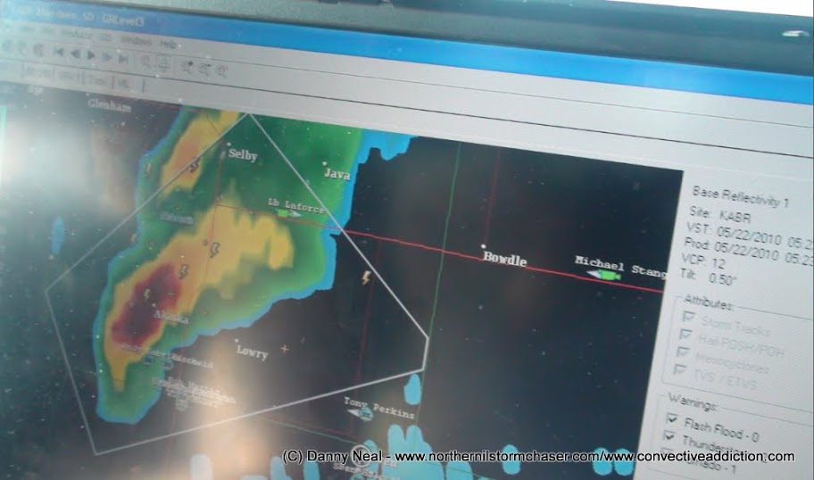
If you are utilizing mobile radar your storm may look like this and in some cases like this one, become immediately tornado warned! As I said you want to approach this cell from the south and east to get into prime position. If you notice the majority of the chasers out there are taking this strategy (including us!)

This is about 25 minutes after the storm broke the cap and took off. Since it was immediately tornado warned you are thinking to yourself it is really show time! You get close enough to the storm and see this in the distance! TORNADO!!! .........WRONG! This is NOT a tornado or a funnel cloud or even a wall cloud! This is the storm becoming more surface based. The updraft acts as giant vacuum. It inhales warm moist air and when this air condenses clouds form. This shows the beginning stages of a wall cloud. It is fascinating to watch as little scud fragments get inhaled into this central area. Keep watching this area though, but don't be fooled by it's pointy ragged appearance. 

We get a little closer and park and watch. We see the supecells core to the right and the rain free base to the left. In the center of the image we see a slight lowering to the cloud base and again more funnel looking tendrils underneath a lowered cloud base. Is this a tornado or a funnel cloud? NO! This is as I had said above, the updraft drawing in warm moist air which condenses into cloud.  Again this is just the process of the evolution of a sustained wall cloud. Keep watching though!

A little further along the time line and the storm is a little closer. Notice any difference? One might say no because the scud has dissipated and now just looks like an ordinary rain free base. However it is important to notice how much LOWER the base has become as compared to when we first started. It is also VERY important to notice the feature on the right hand side. The long laminar looking cloud extending to the right or north. This is known as a beaver tail. It forms along the boundary created by the forward-flank downdraft. The area of precipitation is cool while the area you are viewing the storm from is warm and moist. The beaver tail will form where the two meet and mark it out by a long line of clouds shaped like a beavers tail. It shows that a supercell is starting to get it's act together.

We progress and the storm has moved a little bit to the north and west. An overview of events that are occurring. To the right you see the core. You also see the beaver tail demarcating the boundary. To the left you see the rain free base. But notice that pronounced lowering in the center of the image. There is your wall cloud beginning to form. At this point in time you should be able to tell if this storm is rotating or not. Watch the horizon and watch above you. You should be able to see a slow right to left motion on the horizon and left to right motion above you. A good sign if you are looking for tornadogenesis! Begin to look to the RIGHT side of the wall cloud.... The reason is you should start to see the rapid condensation of scud tags feeding into the wall cloud. This will create a tail cloud and will ALWAYS point toward the rain or core. Also note if the wall cloud has a good circulation or intense rising motions.

Notice how low the wall cloud is now. There isn't a tail cloud evident yet but notice that dark area to the left of the wall cloud. That is your RFD beginning to wrap around the area of circulation! It is time to move north before your viewing area gets cut off by the rain. An RFD wrapping around a circulation is a good sign and has been unofficially linked to tornadogenesis (more often than not). No tornado yet!

Well now we are much closer (maybe too close for newer chasers) Looking just south of due west at a VIOLENTLY rotating wall cloud. It is about to happen. Everyone knows it but are you safe? At this point in time you are in a HIGH danger area but knowing storm motion and behavior you will be able to tell if you need to get out of there or not. Right now I am at an intersection where if this were to drop a tornado and it headed due east at me I can always blast south out of harms way. But knowing the storm was moving ENE I plotted this wall cloud to pass to the west of me and into the field to the northwest of me. Once you realize you are safe, grab you tripod and camera and get ready!

The wall cloud drops a large funnel cloud with dust on the ground! TORNADO?!?!? YES! THIS is a bonafied tornado. Rapid rotation noted with tornadic winds reaching the surface. Just because there is no condensation funnel extending to the ground doesn't mean there isn't a tornado in progress. But if you want that fully condensed tornado... continue to watch the tornado as all tornadoes go through numerous evolutions.

The tornado has now fully condensed and moved safely into the field to your north west! Celebrate your accomplishment! But beware of the beast that is wrapping around the circulation! (RFD)

Now that we have covered how to successfully seek out a tornado, now it is time to post some examples of look-a-likes and why they are NOT tornadoes.


Tornado? Funnel Cloud? Nope! This was shot looking to the NW as the south end of a line of low topped thunderstorms moved by. This was on the leading edge of the line and had the look of a large white cone funnel but looking at the flag you see that the wind is gusting out of the west. This denotes outflow winds and thus ends any chance of a tornado.

Tornado? Nope! This is a the backside of a thunderstorm and what you see is a hail shaft being illuminated by the sun. 

Tornado or no? Yes and No! The feature on the left is the dying La Grange, WY tornado. The feature on the right LOOKS like a large wedge but in fact it was just a large wall cloud. We were over 15 miles away from this tornado so from that distance it looks like a giant wedge.

 Tornado or no? NO! This is just blowing dust out ahead of a bowing line of severe thunderstorms

 Wall cloud or no? NO! Although it is low hanging and could fool some people, it is nothing more than a harmless outflow boundary.

 Funnel cloud or no? NO! This is just scud underneath a gust front. This storm was tornado warned so some may jump the gun and report something that truly is nothing.

 Wall cloud with tornado? Yes! and NO! Yes this is a wall cloud, but no there is no tornado in progress at this time. Remember if you are that far away, odds are what you appear to be reporting is probably incorrect!

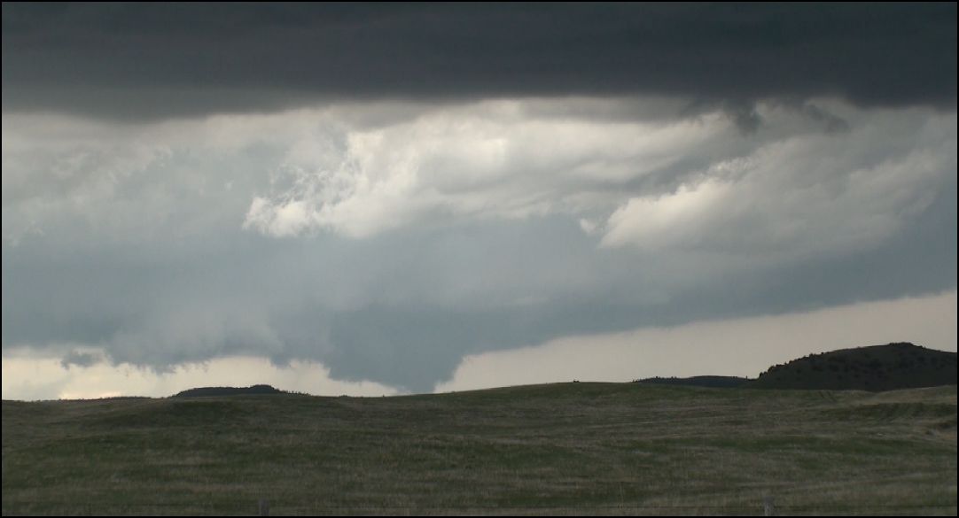
 Tornado or no? Unknown! Yes there is a wall cloud, yes there is a lowering out of a wall cloud, but unfortunately there is a MOUNTAIN obscuring the view of the base. There COULD have been a tornado in progress but as a reporter you would not be able to confirm it. The dangers and difficulties of chasing in Wyoming!

 Beautiful stacked plates supercell with tornado!!!! WRONG! This is a very good look-a-like and may fool some people into thinking a stout stove pipe tornado is on the ground. But if you watch the feature for rotation and how it morphs or changes shape you will realize it is nothing more than an intense rain shaft.

 Tornado or no? NOPE! It may appear a large wedge is on the ground but to the trained chaser it is clearly evident that this is nothing more than rain.

 Just busted out the back side of a low topped supercell. Look to the right and see a beautiful rope tornado out of the backside of the rain shield! Only problem is IT IS NOT A TORNADO! Remember Mother Nature is trying to fool you every chance she gets you have to outsmart her and study her and sometimes she lets you reap some benefit!

Remember.... if you aren't sure... observe. Remember what kind of storm you are chasing, remember where to be to observe a tornado, and remember if it isn't rotating then it should not be reported!!!

Thanks for reading!

27 January 2011

A little reminder: Rotating wall cloud vs Non rotating wall cloud

We are getting down to storm season so for those who like to follow me or the newer chasers out there I am going to attempt to put a little comparison together here to educate a wall cloud vs not a wall cloud. A wall cloud is defined by the AMS as "a local, often abrupt lowering from a cumulonimbus cloud base into a low-hanging accessory cloud, normally a kilometer or more in diameter. A wall cloud marks the lower portion of a very strong updraft, usually associated with a supercell or severe multicell storm. It typically develops near the precipitation region of the cumulonimbus. Wall clouds that exhibit significant rotation and vertical motions often precede tornado formation by a few minutes to an hour." However it is also to be noted that not all wall clouds are tornadic or even rotate! Any thunderstorm can in theory have a wall cloud associated with it. The key is to look for rotation and call in those reports.

Some simple things to think about when you think you see a wall cloud.... First is it in the right region of the storm? Are you seeing a low hanging cloud on the forward flank of the storm or the rain free base? Another question to ask is is this feature pointing toward or away from the rain? Shelf clouds generally point out away from the precipitation while wall clouds generally point toward the rain. I will have examples below. Is this feature rising? Slowly rotating? Intense rotation? Or bowing out? Is it possible to have tornadoes that don't have wall clouds associated with them? Absolutely! It is also possible for HP supercells to produce a wall cloud buried within the notch of the storm near the NE quadrant of the supercell. However unless you are tucked your way into the notch you would never see it from a distance away because you will be blocked by wrapping rain curtains.

I am going to post some photos below about what a wall cloud is and what a shelf cloud is. In each of these photos I will identify the feature, where it was, the direction I was facing, and what was going on at the time the picture was taken.

This is a low-precipitation supercell shot in Western Texas near Floydada on April 21st, 2010. Looking to the south west we have a rotating thunderstorm and 3 inflow streamers flowing from the left to right on the left hand side of the photo. LCL's this day were very high so tornado production wasn't a concern. Underneath the rain free base you see little scud tags that were rising into the storm but it just did not have low level rotation. Therefore there was no wall cloud evident and nothing to be reported.

This is another example (although tougher) of wall cloud vs not a wall cloud. We have a supercell in Southern South Dakota on May 24th, 2010. We are looking south south west with a previously tornado warned storm. The heavy rain/hail is to the right and the updraft region was to the left. This storm was screaming north at 60 miles per hour and had strong inflow. At the point in time where this photo was taken a lowering was evident out of the rain free base. I suppose you can call it a wall cloud at this point but 4 minutes later....
A little better defined lowering was now evident. However the storm rapidly diminished in intensity and eventually fell apart a little after this. The key is to look for rotation. There was very broad/unorganized rotation at this point and was not an imminent tornado producer.

Here is an example of something that someone may call a wall cloud because of the lowerings and sinister looking sky but it is nothing more than a harmless shelf cloud. Photo taken June 18th, 2010 near Janesville, WI. 

Examples of clear cut wall clouds:


Intense rotation was noted in the three images above. Shot #1 was near Groom, TX 4/22/10, Shot #2 was near Farmington, IL 6/5/10, and Shot #3 was near Kiester, MN 6/17/10.

REMEMBER! NOT EVERY WALL CLOUD IS TORNADIC! THE KEY IS TO BE ABLE TO TELL IF IT IS ROTATING! AGAIN ANY THUNDERSTORM CAN HAVE A WALL CLOUD.

Damn you GFS

Over the last few weeks I have been monitoring the GFS progress and handle on systems in the long range. So far my results have been inconclusive but have noticed some interesting flip flops from model run to model run. For example... yesterday's 12z run had mid 40's streaming into Chicago way out in fantasyland. Today's 12z run (24 hours closer) had us at TWO DEGREES!!!!

Tonight's 00z run has KLOT area in a typical La Nina pattern... cold with shots of brutally cold spells and clipper type systems swinging in periodically. No major systems... yet. The GFS paints an interesting storm system for the weekend over the southern plains that may swings its' way into Chicagoland. At the very least those of you in the southern plains are going to get a taste of Spring with a slap in the face by winter within a 48 hour time frame.

Details on the progression of this storm system to follow!

26 January 2011

Playing Poker on FB/Videos finally done converting

Well I had work this morning, ho hum. Another day working in a cooler and unloading produce. I get home and made some damn good lunch and was pleased to see my videos done converting from mt2s to WMV. Started that last night and it went through the night and ended sometime before noon today. I had to do this because Vegas 9 wont recognize my Mt2s videos. I don't understand it. But I guess it is a blessing in disguise since my plan from the start was to do stock sales and I don't want to put high quality stuff out there right now. SD will work just fine for these clips as a sampler... if people are interested I can FTP them the HD video.

So I have been playing some online poker tourneys (free) on facebook with some buddies. It passes the time while I wait for things to render out and upload and what not so if you are on FB poker, come find me. I am normally a pretty good poker player so it is a fun time.

I am not sure how I want to format my web page to incorporate this stock section... or if I want to just use this blog for chases/forecasts and ONLY dedicate my website to stock and sales. Trying to brainstorm. I don't like how bulky youtube makes my web page. I can never format videos the right way (I.E 4 x 4) 16 videos 4 by 4. It usually ends up 1 row of 16 and it is frustrating. I will figure it out I guess. That is all for now!

25 January 2011

Off-Topic - Good people out there!

On November 22nd, 2010 I had my front end wrecked by a guy that pulled out of a driveway and hit me. All was paid for and covered by his insurance he immediately admitted fault and all was well! He was a nice guy about it and since it was all taken care of I decided not to show up to his court case and have ticket dropped. I took my care to Guardian Auto at 89th and Kedzie and was happy with the results I got out of their body work. I recommend anyone that has body work to be done to go there. Well the day I got my car back was my dads retirement dinner at 115. Bourbon Street in Merrionette Park. My girlfriend and I left and got there around 7 P.M. While looking for a parking spot somebody blindly backed out and backed into my front right panel near my wheel. I was absolutely livid. The car that I just had fixed was now hit again 90 minutes after I got it back! To my relief a cop was behind me and saw it and there was relatively no damage. The officer made a report and issued no infractions. He advised us to go through our insurance companies and take care of any monetary damages. I decided it wasn't worth pursuing. The other party involved called me and asked if we could handle any damages out of pocket. I told him it wasn't worth it and to just forget about it, but he insisted in repaying me. I told him I didn't want to take his money for nothing, when he suggested he buys me a couple cases of beer. I agreed and today he dropped them off and I am currently enjoying one! Glad to see that people out there are still honest and I wish this gentleman the BEST of luck in his job as a contractor.

A goal for 2011 - Next couple weeks project

I have decided that I want to dabble in the stock video sales realm. I don't feel like busting my ass to focus on ENG/breaking news video. With the time I will have to edit videos and present them I hope to make at least a couple of sales. The thing about stock video sales is that if you do sell to production companies, you can make a pretty decent chunk of change. You will sell more in streams but make only little chunks of change at a time. I will probably only focus on 2009 and 2010 footage since it was shot with an HD cam and that is way more attractive to the buyer. I don't plan on only displaying severe weather.... I am going to dabble in other disasters and fires as well. I am going to redo my web page and try to insert this blog directly too www.northernilstormchaser.com . As for news with Convective Addiction we are still together and going strong and will have plenty of new features to provide our fans in 2011. We have been quiet because we have been working! Thanks for following!

Blog Part Deux

Well, let's try this again! I never fully kept up with it so I am going to make it a point to try and post something everyday in here and make this an active place where I can express my thoughts and feelings on most all different aspects of the weather and chasing scene.