
June 17th, 2010 - Southern Minnesota Tornado Outbreak

Thursday, June 17th, 2010 - I almost didn't chase this day. Almost. Not because I didn't want to, but because I had a family obligation on Friday, the 18th, at 7 P.M. My usual chase partner Adam Lucio and I talked about this set up for a couple days and decided it would be well worth the trip. However, I needed to make it a one day affair and he had plans of chasing multiple days in a row. Rather than risk going solo and then marathoning it back to Chicago (already on no-sleep) I decided to sit this one out. It was hard to do but in my eyes family comes first.
I made that decision on Wednesday night at 5:30 P.M. I signed on AIM to tell Adam that I don't know if I could make it when Skip Talbot IMs me and asks if I was going to go. He was going, but his Verizon aircard broke, his phone broke, and his robotic camera dome was giving him issues and wanted to know if I would be going. I told him the situation and he made an offer I couldn't refuse. We all agreed to meet at Skip's house, caravan up to his cottage near Montello, WI, chase Thursday, and then we would take turns driving back Thurs night/Fri morning. Rather than giving up a potential great chase day, I immediately agreed. Adam and Deb came and got me at my place and we were on our way. It was only 30 minutes to Skip's house; we loaded up the gear and headed north for Wisconsin. It was around a 4 hour drive from Chicago to Montello. We arrived there around midnight, looked over data, and went to bed.
From the get go I liked southwestern Minnesota. No convection moving through, nice Theta-E ridge, clear skies, 3-4k CAPE, great moisture return and it was a little more removed from the dryline/cold front. Adam pondered if we should go north toward Fargo. I liked my southern target, but could certainly see and understand why he would want to go north. My big caveats with going north were A.) I didn't bring my passport and didn't want to risk being cut off by the Canadian border and B.) I just felt that the window up there would be very small due to the front overrunning the convection and quickly causing it to become linear. I felt southern Minnesota was the best chance to get a long tracked supercell before a squall line from the west overtook it. Turns out Adam, Skip, and I all were right on.
The next morning we woke up at 6 A.M. and grabbed a bite to eat at Sparks grill in Montello. Usually Adam and I never stop and eat breakfast before a chase as we like to be on the road early in case the storms decide to fire quickly. This breakfast place was spectacular. I ordered the corn beef hash and it was just scrumptious. We were in and out of there in 25 minutes and on the road. We wanted to leave early, because everything pointed to convection going up north at noon and the rest of the dry line blowing up by 2 P.M. We were 5 1/2 hours away from Worthington, MN and knew if we left by 8 we would be there by almost 2. We drove west the length of Minnesota only stopping to fuel up in Austin. By the time we got near the Worthington area we started noticed a Cu field to our west and south. Encouraging! Since Skip and I had no data and Adam's AT&T wouldn't allow him to use roaming, we were strictly visual this chase. Skip and I led the charge with Adam and Deb following us all the way to Luverne. It was here that I finally got signal on my cell phone and decided to look at the COD analysis page. The satellite showed 3 distinct bands of TCu stretching from Fargo to Omaha. We thought we were in a good spot; the SPC even MD our area. It was getting close to show time. After only 20 minutes sitting in Luverne, a big cell popped up 100 miles to our north. Adam and I usually have this philosophy that the first cell that goes up is the sacrificial lamb if you will. By that we mean when towers have been fighting the cap for a while and one finally breaks through, the cap eventually wins the battle and the storm never really establishes itself. But having broke the cap it creates a weakness and allows other storms to fire at will. May 22nd, 2010 was an exception. That storm that day blew through the cap and was up to 50,000 feet in 30 minutes.
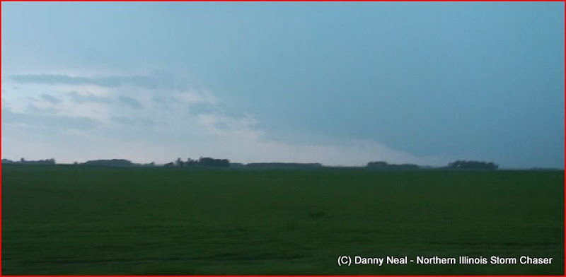
Anyway, we figured the dry line would light up south along it and we would be on the tail end charlie. We sat and waited, huddled around my cheap radar on my 2 inch droid screen. As the next update came in, the storms to north grew and expended in coverage eventually become tornado warned. Meanwhile we were sitting under a baking sun with TCu still firing all over. When would one of these become established? Skip was looking for WiFi so we hunted all over town searching for a hotspot to no avail. We finally gave up and decided to sit and watch the sky. Adam's AT&T finally regained service and we actually had data. The storms up north in North Dakota and northwest Minnesota were making our hearts sink. 9-10 tornado warnings with confirmed tornadoes on the ground 160 miles to our north. To our east a band of showers developed off the supercells in northern Minnesota. At first we thought nothing of them, but when we looked to the eastern horizon we could see massive towers going up from northeast through southeast. I was confused at this point. We were sitting directly on the convergence boundary with good moisture aided by a strong 20 kt southeast surface flow. CAPE was up to 3,500 and the cap was virtually gone according to mesoanalysis. Nevertheless we sat and watched as tower after tower to our east went up and anvil-ed out. Finally we threw in the towel on the Worthington-Luverne target and decided to make a run at the now severe warned line developing.
Visually they looked linear from behind. There were so many rock hard updraft towers in such a confined space along the eastern horizon. We thought for sure the dry line had advanced much further east than thought and was now just firing off one big squall line. We had great low and mid level flow, but the upper level flow was wacky. We started getting that sinking feeling in our stomach that we drove 9 hours from Chicago only to bust on linear storms that were 50 miles to the east of us and heading to the northeast at 50. Instead of pouting and throwing in the towel we all decided to floor it east on 90 back to Worthington before going up toward Windom. Along the way, the northern most cell in the line became tornado warned and broke away from the trailing convection. It was a good 100 miles to the north and we figured we wouldn't have a chance at it. On my phone radar it looked like the stuff to the east and southeast had become one big severe warned QLCS.
After getting to Windom, we continued east in hopes of punching through the back end of the line and reappearing out ahead of it just to get a shelf cloud shot to somewhat salvage the chase. I didn't know what was warned and what wasn't so I pulled up COD's severe weather warnings page. As I figured the cells we were on were severe warned with a plethora of tornado warnings for the storms way up north. After a couple of more refreshes I was shocked to see a tornado warning pop up in extreme northern Iowa. Hmmmm. I pulled up Des Moines radar (on COD's 1 km radar site) and was pleasantly surprised to see a cell pop up within the last 30 minutes and become supercellular. I wasn't sure if Adam was aware of it and told him that Skip and I planned on dropping south and east for that storm and ditching the cells in front of us.
He was on top of things and too noticed the cell and already figured out a route to it. Getting to this storm meant core punching one of the severe warned ones. Not a big deal. We hit it from behind just southwest of Mankato and noticed a lot of turbulent motions going on with a rather high base. Scud was being inhaled almost off the tree tops while CG absolutely littered the emerald prairies. The storm we were core punching was become surface based. We didn't want to hang around and play with it though. We knew that the tail end charlie was 25 miles to our south southeast and that the current cells inflow would contaminated by the outflow from that storm. I had lost cell signal just north of Blue Earth and called Adam for an update. We said the core of the tornado warned storm would be over I 90 in 45 minutes. We were 3 miles north of I 90 so I wrote it off and encouraged Skip to continue on to 90 and then shoot east. Well little did I know was that Adam's radar had timed out on him and it was nearing a half hour old! We got on 90 and went east about 2 miles before we got slammed from south by a 50 kt crosswind. Almost immediately heavy rain and small hail was peppering us on 90. We needed to punch it east and get ahead of it. Not an easy thing to do while battling 50 kt winds, blinding rain, scared motorists and a storm moving northeast at 50 miles per hour. For 10 minutes we battled this thing and finally won just north of Kiester.
We pulled off at exit 134 and followed that east a mile until we turned south on SR22 and headed south for Kiester. Upon arriving in town a lowering was evident 5-6 miles to our west. We nudged up the road a bit to get a better look at this lowering. I actually got out of the car and attempted to stand on the bumper to get a better view, until a CG barrage unlike any other started raining down near us. Not the most ideal setting to film needless to say I quickly retreated back into the car. After a few minutes it was clear that this lowering was not rotating and was actually being pushed out at us by outflow. However, we noticed a new cell merging with this storm from the southwest. I never got a picture or video of it (I should have) but it was a beautiful little LP structure with a tiny rounded base that was 2-3 miles removed from the former storm. We went back north through Kiester and back east on County Highway 46. Upon doing so Adam, still behind us, texted me saying Roger Hill had a tornado out of that merging cell. I looked back and couldn't see anything as precip was now falling and obscuring my view. I told Skip to punch it east and we did. Out of the rain I began to see the base again and a nice little lowering. I yelled at Skip that we may have something but needed to get east for a better view. He obliged and we made it to 640th Ave. before turning south.
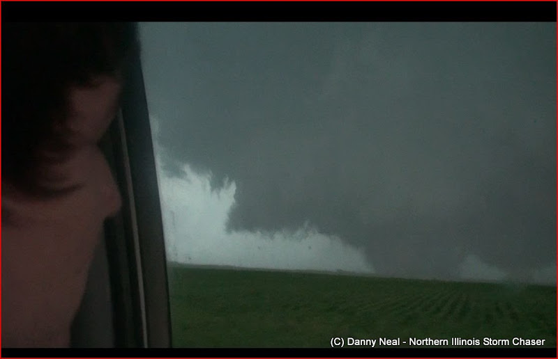
As we traveled a mile or two I began seeing what I thought was a cone funnel coming down. I couldn't be sure since we were dodging trees and houses and only could get a brief glimpse of it. Finally as we crested a hill, we saw a magnificent cone tornado 7-8 miles to our southwest. We continued south on 640th watching the tornado get a little bit bigger. A couple of more trees blocked our view of it and when we re-emerged the cone had changed into a slender stovepipe to the left. That tornado dissipated and another cone lowering started to descend. The lowering immediately came down as an elephant trunk tornado. At first I thought it may have just been the same tornado, but as we approached the circulation it was CLEAR that there were 3 areas of intense rotation. The tornado was on the left side of the meso with a new cone lowering coming down on the right. After 30 seconds we had both tornadoes on the ground at the same time. We witnessed three tornadoes in a matter of 10 minutes. We knew the storm wasn't done. Not by a long shot.
The former tornado lifted while the new cone churned away several miles to our southwest. The contrast was poor and we contemplated moving toward the west on one of the county roads. I thought the way to improve contrast was by continuing south and this was certainly the case. The cone lifted after a minute or two. We pressed on and noticed a very large wall cloud was now evident. At this time we made it to 650th Ave. and 140th St. and were looking at a tornado very near Kiester. We set up shop here for well over 20 minutes as these circulations approached. As the multi-vortex moved just to the north of Kiester it wedged out into a very large tornado directly west of us. Tornado maxed out to almost a mile wide as it moved east northeast very near Kiester. The motions were violent as violent can be. CG's were crashing down everywhere with multiple bolts striking very close to us. The tornado continued to approach our location and continued to be extremely violent. This will be a very high rated tornado I am sure. As the tornado approached it began to inhale and absorb its own tail cloud on the north side. Cumulus clouds were being thrown into the wedge as it neared our location. I called 911. We didn't have data or a ham radio so I couldn't make Spotter Network reports. The only thing I could do is dial 911 and report everything I could and I did for the majority of the chase. Nevertheless, despite the warnings I was giving thewedge continued to move northeast away from Kiester.
As the wedge approached, it lifted but there was still a multiple vortex circulation on going so in my mind it was still on the ground. I zoomed out to try to get a perspective of the structure just as a fat cone fully condensed underneath the left side of the wall cloud. The old circulation that produced the wedge was still producing a multiple vortex tornado. A new circulation developed very close to us just west of us. This photo illustrates the older circulation in the background and the never circulation in the top left-center. We watched both circulations spin violently with the old circulation still putting down fully condensed tornadoes. These were not separate tornadoes, rather spin ups from the same circulation. At this point we tallied a total of four tornadoes. CG's were still pouring out of this storm. What a crazy/intense supercell; we knew it was going to produce something nasty. The old circulation dropped another large condensation behind the trees (still parent circulation - still counting it as same tornado) while the new circulation kept dropping a cone funnel. I couldn't see behind the trees, so risking getting hit by lightning, I ran out of the car and down the road to see what I could see behind the trees. Once I got to the edge of the trees I was AMAZED at what I saw 3 miles down the road. Still part of the same Kiester circulation and was fairly long tracked although with intermittent damage. The old circulation was still producing while the new one was still rotating violently. This new circulation dropped an amazing white cone while the old circulation was a multiple vortex cone.
The cone was brilliantly churning in the field across the road from us as the old circulation finally occluded. This tornado was number 5 on the day, but quickly retreated back into the cloud base all the while the ground circulation was still evident. We sat there and watched for two minutes waiting to see if this cone would come back down. The rotation was definitely supportive of this. Finally all at once a massive stove pipe crashed down just behind a farmstead a mile to the north northwest. I zoomed the camera in here as I wanted to see the perspective of it to the farm stead. Very close call but this property was spared. The tornado quickly wedged out underneath some of the most jaw dropping structure known to supercells. I was in awe. A day so busted on our part turned into something so treasured. As the wedge moved to the north northeast the structure just continued to get better and better. I couldn't believe it. I again called 911 to tell them a large tornado was on Conger's doorstep. It was obvious that they probably knew about it since the area was littered with law enforcement and emergency vehicles but I wasn't taking any chances. We hoped in the car and went back to 140th and took that east one mile to 660th Ave. As we turned north the tornado had morphed back into a big cone funnel with debris whirl. The tornado then turned back into a fat cone just southwest of Conger. The tornado became stationary for a while, with power flashes and whirling debris. We nudged north another mile as the tornado widenedeven more. We noticed a road block up ahead and decided to turn around and take SR 15 east until it curved north into the town of Conger. We had hoped Conger wasn't hit but that large tornado was perilously close. As we moved into town it was clear that it missed Conger, barely, to thenorth.
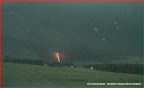
We turned east out of Conger as the tornado wedged out again. A satellite tornado danced around it as it moved in the general of Albert Lea. It turned back into a big white Manchester-like conebefore wedging out again. As we were looking for roads, I zoomed out and too my horror realized this tornado was dead set on hitting the west side of Albert Lea. We continued up the road where police had blocked the road. We sat there for 3 minutes waiting when suddenly the police officer started waving us through yelling the tornado had turned and was heading for us. There was a grove of trees blocking our view so I had no idea if this was true or not. Nevertheless we made the ominous drive through Albert Lea. When we re-emerged out of Albert Lea on the east side we realized that rain had obscured our view of the tornado and we need to head back west and south a little. We set up just southeast of the town of Hayward and saw another lowering. The Albert Lea - Conger tornado had lifted in the 20 minutes we were in town, but this new lowering was near if not over Albert Lea. Suddenly another tornado dropped and we had our 7th of the day! We decided to go north, but the tornado dissipated. We figured it would be a great idea to keep up with this circulation as it headed north in case it dropped another tornado. Little did we know amonster was already on the ground in the rain. Lightning sparked out of this great beast as it grew up to 3/4 of a mile wide. We advanced on the tornado as it neared Hollandale. The tornado then transitioned into a slender tilted stove pipe and finally roped out. We followed the storm north into Blooming Prairie unable to see anything else and called it a chase!
Tornadoes: 12
Hail: 1.00
Wind: 40 mph inflow
Close CG's: too many to count
Strongest tornado: EF-4
PICTURES:


No comments:
Post a Comment