
Welcome to Danny Neal's blog. On here you can find chase reports, forecasts, photography and news
03 April 2011
Sweet revenge will be ours.... for the taking
Got off work early (THANKFULLY) and was now able to chase today! Was gonna be at the fire house until 6 P.M. but ended up getting out earlier. So 2011's first chase is now underway with Adam Lucifer and Matt Cumberland. We are currently on I 80 near Ottawa, IL heading toward the west to a more favorable area. At this point it is a tough call, I really want to stick to my target of Donnellson, IA, but am getting baited into the idea that we should just follow the warm front into oblivion. Right now we are hitting the mid level cloud deck floating in out of IA, but see some nice clearing to the S and SW. CAPE should be building into the 3,000's. SRH values pushing 200 m2/s2, and boundary layer Td's in the mid 60's spell a volatile situation. Warm 700's will suppress the convection until later afternoon. I am expecting the cap to be breached in two areas. #1 - Near the triple point in E IA, NW IL and #2 along the cold front stretching near KCMO. I am not *too* confident in a robust tornado threat today, but I hope I am wrong. QLCS mode most likely, we may hedge into N MO. I do not like the wide T/Td depressions so I truly hope those mid 60 dews advect into the area. Still on the road through La Salle/Peru. Check back here for updates as they happen!

02 April 2011
April 3rd, 2011 - Chase forecast blurb 0z - IL/MO/IA
Severe weather will probably happen at some point across the Central Plains into the Mid MS River Valley. A pretty dynamic and fast moving system is on our hands. With each model run the CF has sped up and splitting hairs on whether Sunday or Monday will be the day. Sunday's set up has been looking absolutely yummy except for one glaring issue. The CAP/EML/Inversion *insert term here*. The Lid Strength Index has areas in the warm sector in the 3-4 range. As a rule of thumb I go by, 0 - No Cap, 3 - Strong Cap, 5 - GOOD LUCK! Most of the area have been in the 2-3 range with hints of a hole opening up before filling back in at night. The 0z NAM has a big hole of 0 to -1 LSI opening up right over Burlington, IA. Low-level instability is pretty robust as well. The low-level lapse rates could be better, but we aren't asking for the perfect set up.... or are we?
As another rule of thumb I have learned over my years chasing is that YOU DO NOT IGNORE AN ILLINOIS WARM FRONT!!! No matter how strong a cap, how favorable the wind shear is in another state, or what the SPC is targeting. If there is clearing, plus a boundary/warm front, and you start mounting instability and your indicies are raising....then your ass needs to be parked under that Cu field. EHI's are looking much better near Kansas City, but the cap fails to erode whatsoever back there.
So what does this mean? All I am doing is spitting out indicies and numbers from what the models say.... I am saying this. With projected 1700+ SFC based CAPE, an eroding cap, meager low level lapse rates, and decent wind shear, we may be looking at the first tornado threat for N. IL for the 2011 season.
Pros:
*60 degree dews nosing in
*Temperatures in the low to mid 70's
*Appreciable instability nearing 2,000 J K/G
*Slightly backed winds along and just to the S of the WF (depends if a secondary low develops in IA to wrap more moisture into the system and further back the winds
* An eroding cap (possibility)
* Low level jet ramping up
Cons:
* CAP
* No real forcing mechanism outside of the CF itself later at night
* Veered flow throughout the majority of the warm sector.
* Twilight chase perhaps
* Fast moving progressive system - by the time the next set up model runs come out, the threat could be in W IN for all we know.
To conclude, we would be looking at a major severe weather outbreak Sunday afternoon into the evening if the EML/700 temps/CAP/LSI/WHATEVER wouldn't be in Mid-June Iowa form. The most likely scenario is chasers will get a nice sun tan in a fast food joint of their choice. With a dryline likely to be intersected by the quickly moving cold front; thunderstorms should erupt after sunset in E IA down into E KS and move ESE along the front. Main threats would be damaging winds and hail. However, if the previous ingredients fall into place and a breach of the cap occurs, we could be looking at a couple isolated supercells from SE IA toward the KC area. A tornado threat would exist with these storms as a S low level jet enhances the low level shear. But the latter half of this forecast at this point in time is still <10% certainty.
Final prediction;
Virtual target: Donnelson, IA (I have work on Sunday so FAIL I can't actually chase it)
Ideal scenario: Supercell develops 21z in N. MO. Crosses the MS River near Ft. Madison and tracks along the WF into N IL. Producing photogenic tornadoes in the open farm land.
Official Forecast:. TCu galore with a struggling storm by sunset near Burlington, IA. With the projected LSI weakening, there is a small window for this storm to become supercellular and utilize meager low level instability and briefly become surface based and hopefully root on the WF. Otherwise the aforementioned erosion of the cap will allow for explosive thunderstorm development along the WF and CF stretching an MCS from NW IL to E KS. Severe winds and hail will be prevalent after 02z and reach me in Chicago perhaps toward 04z.
Total tornado reports: <7
Total Hail reports >30
Total Wind reports >60
Been a while since I have done one of these, I have to knock the rust off sometime. Let's hope my forecast won't bust!
As another rule of thumb I have learned over my years chasing is that YOU DO NOT IGNORE AN ILLINOIS WARM FRONT!!! No matter how strong a cap, how favorable the wind shear is in another state, or what the SPC is targeting. If there is clearing, plus a boundary/warm front, and you start mounting instability and your indicies are raising....then your ass needs to be parked under that Cu field. EHI's are looking much better near Kansas City, but the cap fails to erode whatsoever back there.
So what does this mean? All I am doing is spitting out indicies and numbers from what the models say.... I am saying this. With projected 1700+ SFC based CAPE, an eroding cap, meager low level lapse rates, and decent wind shear, we may be looking at the first tornado threat for N. IL for the 2011 season.
 |
| *LSI down to 0 and -1 over target area |
 |
| *Instability nosing into the TA |
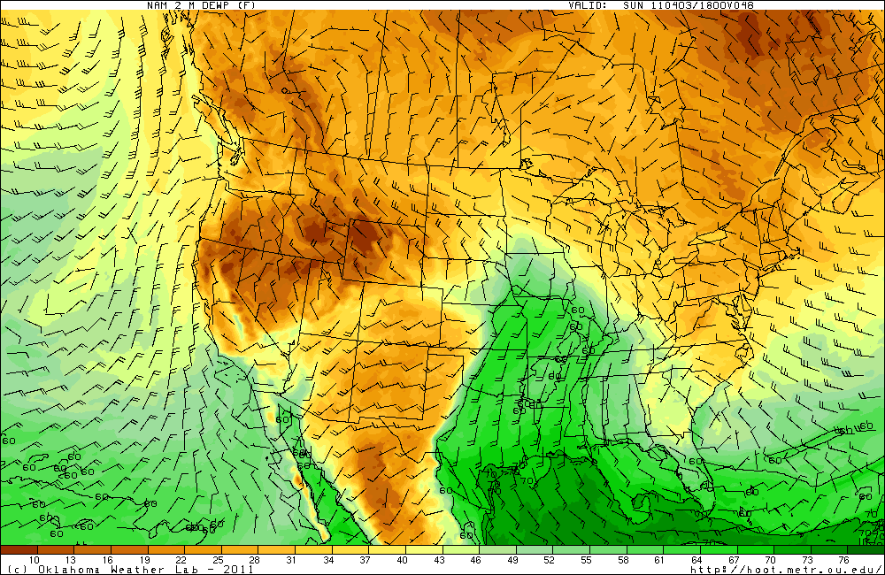 |
| *Moisture return feeding into the TA |
*60 degree dews nosing in
*Temperatures in the low to mid 70's
*Appreciable instability nearing 2,000 J K/G
*Slightly backed winds along and just to the S of the WF (depends if a secondary low develops in IA to wrap more moisture into the system and further back the winds
* An eroding cap (possibility)
* Low level jet ramping up
Cons:
* CAP
* No real forcing mechanism outside of the CF itself later at night
* Veered flow throughout the majority of the warm sector.
* Twilight chase perhaps
* Fast moving progressive system - by the time the next set up model runs come out, the threat could be in W IN for all we know.
To conclude, we would be looking at a major severe weather outbreak Sunday afternoon into the evening if the EML/700 temps/CAP/LSI/WHATEVER wouldn't be in Mid-June Iowa form. The most likely scenario is chasers will get a nice sun tan in a fast food joint of their choice. With a dryline likely to be intersected by the quickly moving cold front; thunderstorms should erupt after sunset in E IA down into E KS and move ESE along the front. Main threats would be damaging winds and hail. However, if the previous ingredients fall into place and a breach of the cap occurs, we could be looking at a couple isolated supercells from SE IA toward the KC area. A tornado threat would exist with these storms as a S low level jet enhances the low level shear. But the latter half of this forecast at this point in time is still <10% certainty.
Final prediction;
Virtual target: Donnelson, IA (I have work on Sunday so FAIL I can't actually chase it)
Ideal scenario: Supercell develops 21z in N. MO. Crosses the MS River near Ft. Madison and tracks along the WF into N IL. Producing photogenic tornadoes in the open farm land.
Official Forecast:. TCu galore with a struggling storm by sunset near Burlington, IA. With the projected LSI weakening, there is a small window for this storm to become supercellular and utilize meager low level instability and briefly become surface based and hopefully root on the WF. Otherwise the aforementioned erosion of the cap will allow for explosive thunderstorm development along the WF and CF stretching an MCS from NW IL to E KS. Severe winds and hail will be prevalent after 02z and reach me in Chicago perhaps toward 04z.
Total tornado reports: <7
Total Hail reports >30
Total Wind reports >60
Been a while since I have done one of these, I have to knock the rust off sometime. Let's hope my forecast won't bust!
28 March 2011
After an absense .... I am back.
Hello all,
I am still alive! It has been a peaceful four weeks. We had a huge chase party at Skip Talbot's after Sean Casey's premiere of Tornado Alley. We went to see it on Saturday afternoon and were surprised by Sean and Jennifer Casey! Jennifer Casey asked us to stick around and wait for Sean to get done greeting his fans so we can have some one on one time with Sean to shoot the breeze. Chatted with him for 30-45 minutes before leaving for party time!
To be clear, I was never an over the top Casey fanboy, but it is well known I like him better than the others. For him to stick around and WANT to talk with the group of chasers like he did was a great move and I am definitely a Casey fan now. He has some great new plans and new technology he will be using, I can't say much because I don't want to ruin anything, but it will be cool to see what happens in the next year or two.
After we met with the Casey's we went back to Skip's house and partied. It was a good time. Ben was drunk again, got to meet some new faces, and reminisce about the previous season. Convective Addiction will be out there and primed to dominate the plains again.
Overall life has calmed down. Been working my new job and getting bank for it! I think I have enough for some chasing this year! Not going to be out as much as I was last year so I am going to make these chases count. Eying this coming weekend..... More to come!
I am still alive! It has been a peaceful four weeks. We had a huge chase party at Skip Talbot's after Sean Casey's premiere of Tornado Alley. We went to see it on Saturday afternoon and were surprised by Sean and Jennifer Casey! Jennifer Casey asked us to stick around and wait for Sean to get done greeting his fans so we can have some one on one time with Sean to shoot the breeze. Chatted with him for 30-45 minutes before leaving for party time!
 | |
| A pic snapped of Sean and I talking about his upcoming plans! I won't spill the beans but I think you all will LOVE it! |
 |
| Another pic of Sean and I gabbing about TIV2 |
To be clear, I was never an over the top Casey fanboy, but it is well known I like him better than the others. For him to stick around and WANT to talk with the group of chasers like he did was a great move and I am definitely a Casey fan now. He has some great new plans and new technology he will be using, I can't say much because I don't want to ruin anything, but it will be cool to see what happens in the next year or two.
After we met with the Casey's we went back to Skip's house and partied. It was a good time. Ben was drunk again, got to meet some new faces, and reminisce about the previous season. Convective Addiction will be out there and primed to dominate the plains again.
 |
| Chillin' watching some DVD's |
 |
| Me giving Adam a hard time for begging Sean for an autograph! :D |
Subscribe to:
Posts (Atom)