
May 22nd, 2010 - Northern South Dakota Tornado Outbreak/Field Incident

We had been watching tCu for a little over an hour up to this point. Each updraft tower would reach higher into the sky before ultimately collapsing. Very discouraging since the main caveat to today's chase was a pretty stout cap. We knew that IF a storm broke it it had the opportunity to go insane in an extremely favorable environment. As we were gassing up in Gettysburg, SD, our persistent updraft finally exploded and became QUICKLY tornado warned.


The cell was exploding before our very eyes! It went from a large mass of cumulus congestus to a full blown monster in 25 minutes time. The storm finally tapped into the cold air aloft and continue growing tapping into all the cold air aloft. The anvil soon reached across the whole eastern sky!


We went east out of Gettysburg and turned north toward Hoven. As we got to Hoven the base was in clear view off the west near Akaska. NWS surveys confirm a tornado touchdown at this exact time and this certainly looks like a funnel cloud. However I do NOT believe this was a tornado because there isn't a well defined wall cloud. I think what we have here is the initial lowering that would become the storms first wall cloud. Beautiful landscape!


Pretty insane structure at this point. This supercell, still in its infant stage, had text book structure! We sat and watched the supercell mature for 20 minutes! A wall cloud tried to form in the image to the right. I sat and had this evolution tripoded which I plan on timelapsing as time permits!


The next several images (viewed from left to right) shows the evolution the first sustained attempt at a wall cloud. In image 1 rising motion was noted and inflow into the storm was around 15 kts. In images 2 and 3, more scud is drawn into the cloud base and a beaver tail is trying to form on the right. Images 4 and 5 show the wall cloud slowly getting its act together and a quickly developing beaver tail. Also in image 5 you not more scud tags rising into the cloud base. In the last image you can make a well defined beaver tail on the right feeding into the mesocyclone. There was only broad rotation noted at this time


As time progressed (matter of 5 minutes) the supercell really started to get its act together. The wall cloud was now very pronounced. The first image shows a beautiful beaver tail feeding into the mesocyclone with a well defined wall cloud that started to exhibit strong rotation. The second picture notes a very ominous looking wall cloud that we could tell was on the verge of producing. The bottom images depict a strong RFD wrapping around the mesocyclone. Because of this Adam, Ben, Scott, and I decided it was time to move north to try to keep our visual and to get a closer look at the ground.


While we traveled north on SR 47, it was evident that a tornado may drop at any time. We found a dirt road and turned onto it and faced west to tripod the intense rotation located about 2 miles to our west. In picture two, Andrew Pritchard is seen standing outside his vehicle with a large funnel cloud descending for the ground. I guess technically at this point it could be considered a tornado as evidenced in picture three. The middle block of images show the rapid development of a fully condensed tornado. Andrew actually vacated his spot for SR 47. As he did this the funnel dropped and a tornado was born. Pictures 7 through 9 show a beautiful cone tornado at close range. At this point we are looking due west. The tornado was only a mile down the road from us. The RFD was quickly wrapping around the meso, so we jumped back into the car and floored it up SR 47, paralleling the tornado.


The tornado started moving more east northeast than due north at this point. We pulled off about a mile up from where we were previously sitting. We watched as the tornado weakened as it occluded near 47. Apparently at this time the TIV made a successful intercept without Sean Casey in command.


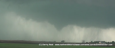
Not wanting to drive under the violently rotating wall cloud, I got out and filmed as vorticies danced underneath. As I mentioned before, this storm featured an extremely strong RFD. Winds ranged from 40 to 60 kts! Waves of windblown rain rotated around the mesocyclone and blasted us from the west. It was at this time that the initial touchdown of the infamous Bowdle wedge occurred.


Once the tornadic circulation crossed the road, we continued north on SR47. Now looking northeast, I saw what appeared to be a large wedge tornado in progress. I wasn't sure due to the fact I was trying to look through a wet RFD. Once we cleared the wrap around precipitation, a clear view of a white cone tornado came into view. It was at this time that the tornado was crossing US 12 and Tim Samaras was deploying his turtle probe!


The tornado was now well east of the highway and we had a great intercept route planned out. All of a sudden there was a line of brake lights in front of us. We couldn't believe it. After three minutes people started turning around and we did the same. The tornado damaged power lines and we needed to turn around and find an alternate route. This greatly hampered our efforts to get a good shot at the wedge.


We found an east route and picked our jaws up off the floor of the car. The sculpting of the updraft was lit up by the sun and allowed us to see into the jaws of this storm. A wedge tornado was in progress at this time, but it is tiny in comparison to mountains of clouds involved with this beast. In the pictures above imagine the right side of the image pulling toward the left and the left side pulling toward the right. It was all wrapping up in the center of the image. Even from this distance, violent rotation was noted. Everything was in constant motion.


As we made our way north on the dirt roads east of SR47, the beast was lurking underneath the monstrous supercell. Although it was not the view of the wedge I had desired, I am just thankful I was able to capture it. It was also at this time that we realized how close to disaster the town of Bowdle really was. As we drove through town, with sirens blaring, the view to the north was just filled with MASSIVE tornado. Had this tornado hit the town of Bowdle it could have reached EF5 status. I have no doubt in my mind about this.


As we passed through Bowdle, we saw a line of chasers coming south with the faint image of a wedge tornado back there. As we continued east on US 12, we got ahead of the RFD again and easily make out the 3/4 of a mile wide tornado. In our minds we thought this tornado was hauling due to the fact that the first tornado we saw was easily moving 30-35 kts. As it turned out we floored it east while the tornado seemingly stalled 1.5 miles north of Bowdle. We didn't exactly get the money shot of this tornado, but we got a unique shot from Bowdle that only the residents of the town would have received.


We were 5 miles east of Bowdle at this time and realized we were outrunning the storm. The wedge in these photos was either dissipated or dissipating. If it were to still exist it would be back in the far bottom left corner of the set of images. As we drove toward Roscoe we noticed what could possibly be another tornado dropping. I think it was just a nice lookalike though. The supercell was an odd beast. It transitioned from classic to HP at least 3 different times. At this time it was trending more HP. Because of this we decided to drive north a little bit to position ourselves in the notch.


The next several images are of the most beautiful tornado I have ever seen. As we turned north off of US12 the rain cleared out from the base and a slender cone funnel began to descend. The tornado snaked its way to the ground and moved slowly to the east a few miles away from us. Simply a breathtaking view. Hard to believe a storm that produced a tornado so sinister could also produce a thing of beauty minutes later.


The tornado started to dissipate but the supercell exhibited the "mothership" appearance. Scott Bennett was definitely enjoying himself! The storm started to transition back to an HP. This is partly because this beast of a supercell would inhale anything else that tried to develop anywhere near its environment. Whenever a storm went up it would be drawn into the supercell and get absorbed into the updraft. So the storms this supercell was inhaling would rain into the updraft area and appear that storm was wrapping itself up in precipitation.


As another storm was being absorbed into the circulation, tornadogenesis was occurring again. This is a prime example why storm chasing and tornadoes in general can be so dangerous. As evidenced in the last shot this tornado was now completely wrapped in rain. Unsuspecting motorists or residents would see a giant rain shield moving in and be completely unaware that a tornado was again lurking within. We jogged back south to US12 and east to the town of Roscoe where we attempted to once again jog north to get into the notch.


We passed through Roscoe with sirens blaring and positioned ourselves 3 miles north of town. We were in the notch with strong inflow from the northeast. This may or may not be the continuation of the rainwrapped tornado above, but there was definitely a multiple vortex tornado on the ground during this time. The circulation itself was very tight. Rain was wrapped around the entire meso, but it wasn't heavy. The most interesting to note during this time was the inflow gusting to 50 kts out of the north. I have never experienced this before. The airflow around this supercell was just insane. Our route back south to Roscoe was now cut off by the RFD, so we analyzed our dirt road options. We figured we had three options. Option 1 was just to brave it and punch back south to US12 through the RFD. Option 2 was to go north to the next paved road. That road was 4 miles to the north and would have put us in the core. We weren't really feeling that due to the fact that heavy rain and large hail were likely contained in there. So option 3 was follow the dirt roads and zig zag our way the 5 miles to the next paved south option, then back east on US12. The storm was moving at 15 mph so it seemed like a no brainer that we could execute option 3 to perfection.


We reached a T in the road. Once again we were faced with the decision to go north into the core or south out ahead of the circulation. We had given ourselves enough distance that we thought we could safely dart south a mile before heading east again. We met up with L.B. LaForce, Bill LaForce, Bob Hartig, Mike Kovalchick, and the Oosterbans at this intersection. We all had the same general idea. The storm was again featuring classic characteristics so it was clear where the area of interest was. As we sat at that intersection L.B. had returned Adam's tail light that was blown off by the intense RFD of the earlier tornado. In doing so L.B.'s hat blew off. Adam chased after it and eventually tracked it down and returned it to him. I noticed that a new wall cloud was forming VERY close just off to our south southwest. I recommended we get out of there to our south option two miles to the east. This is when disaster happened.
We got 1/4 of a mile down the road when we saw headlights heading back at us. We thought "that's odd, who would be coming back toward this area" The line was led by Bob and crew, then Scott Bennett, and then us. The vehicle turning around was an English chaser by the name of Nathan Edwards. The road was sloppy but drivable. As we got a mile into the road all of a sudden we see Bob and gang turning around. Well that is odd. Why are they turning around? Almost instantaneously Ben screams "TORNADO BEHIND US." So Scott and I continued on only to find out.... THERE WAS NO ROAD! It went from dirt road to green grass to crop. #@$@#!!!!!!
In a state of confusion 6 more vehicles piled up at the dead end of this "road." We were all screaming at each other "WHAT IS GOING ON!!!" All of a sudden Ben screams "ANOTHER TORNADO!, TWO TORNADOES!" To my horror I turned around to see this beautiful drill bit tornado (seen below) to our west northwest and a menacing stove pipe (also seen below) to our west southwest.


We were in a crisis. There was no where to go and no where to hide. A second later, headlights appeared on the horizon. It was NWS DDC meteorologist Mike Umscheid. He is an excellent photographer and was getting amazing pictures before he plotted the same escape route that we had. Unfortunately the road had other thoughts. As we all bottle necked at the end of the road, it was TVN Team Thunder that decided our best option to survive was to bail into the farmers field and cut across to the main road a mile to the east. It was now or never, do or die. We did. We were sliding all over the place having a very hard time navigating the the swampy field. As we reached the end of the fence line, we all turned south knowing the tornadoes we moving east north east. We had to get south and out of the path. As we got into the field a quarter of a mile south of where the road was "supposed" to be, another magnificent rope tornado dropped very near us. Luckily it was to the east of us and moving away.


As we were heading south, we noticed a pond was blocking our egress. It was time to sit and wait it out and pray for the best. I nervously filmed out the window as a wall cloud was clearly visible rotating directly on top of us. Within minutes a scary tornado dropped no more than 50 yards to our east. TVN Team Thunder was closest to this tornado and I am sure got magnificent footage if they weren't taking shelter under their seats! Multiple vorticies danced about all over the field just around to our east. The most terrifying moment imaginable. Thankfully we came away unscathed. The last image shows the velocity couplet at the time of our field experience.
After the tornado, flooding rains fell for almost 45 minutes as we all tried to free ourselves from the field. That was not happening and we all called for help. After a long wait we were finally saved by Bart Comstock. We ended up paying the farmer 400 dollars a person for the damages we caused and walked away with out lives! An unforgettable day!
Thanks for another great writeup and all the pics, Danny. That chase was the absolute motherlode in terms of overall experience. It's good to get your perspective on it. So much happened so fast, and so many tornadoes were dropping around us out in that field--more than I realized. I never saw the one spin up by the vehicles until I watched Adam's video, and my jaw hit the floor. What a magnificent, beautiful, powerful, and terrifying beast the Bowdle supercell was!
ReplyDeleteHere's hoping for some equally amazing storms this year--with maybe a smidgin less drama. ;0)
--Bob